Drone Cut & Fill Surveys for Earthworks
Measure earthworks progress and understand how much material needs to move.
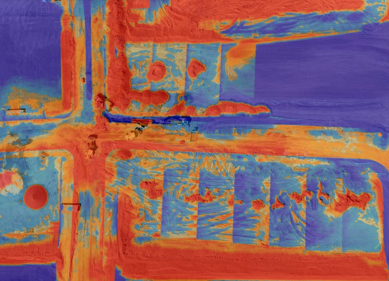
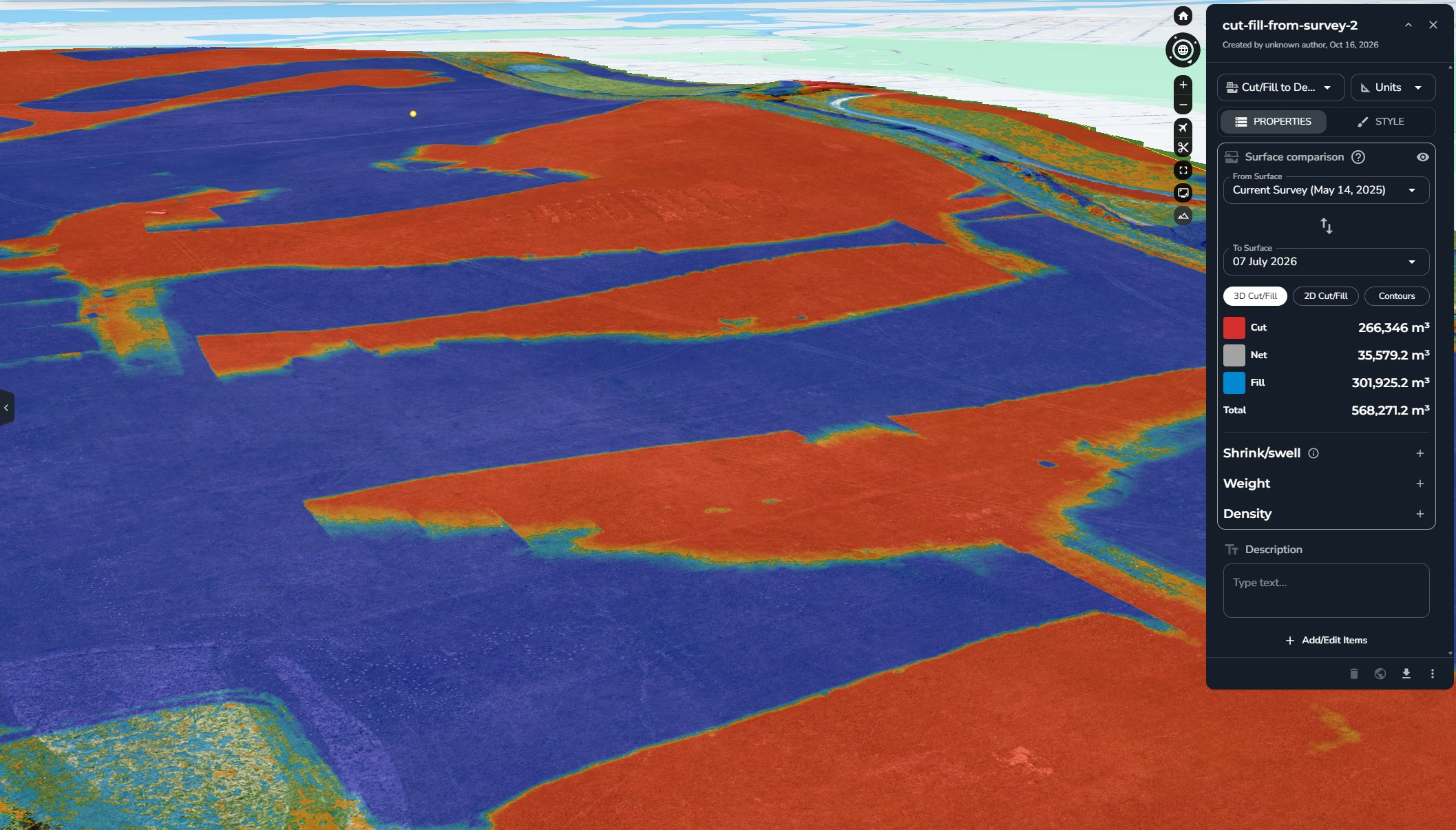
Droneacres compares the surveyed ground with your design surface or an earlier survey. A colour-coded heat map shows where the ground sits above or below the comparison surface, and the report gives cut, fill and net volumes in cubic metres (m³) for planning, valuations and progress checks.
Indicative priceFrom £950 + VATWhat affects the price
Prefer to talk it through? Call 07970 393381.

Cut and fill, explained simply
Cut is ground that is higher than it needs to be and has to be dug away. Fill is ground that is too low and has to be built up. A cut and fill survey measures the current ground and compares it, point by point, with a second surface to show where each is needed and how much material is involved.
Which second surface you use depends on the question. Comparing with the design shows the work still to do. Comparing with an earlier survey shows the work completed between two dates.
What the ground can be compared against
- Proposed design surfaces
- Original ground levels
- A previous survey date
- Agreed formation levels
From surfaces to volumes
The 3D comparison shows where the ground sits above or below the comparison surface, with the cut, fill and net volumes in cubic metres. The diagram shows the same idea in cross-section.


What you receive
- Cut volumesPDF, CSVMaterial to be removed, in cubic metres
- Fill volumesPDF, CSVMaterial to be placed, in cubic metres
- Net volumePDFThe balance between cut and fill across the area
- Cut and fill heat mapPDF, GeoTIFFA colour-coded map of where ground is high or low
- Surface comparisonLandXML, GeoTIFFThe two surfaces compared, with the dates or design used
- Cross-sectionsPDF, DXFSections through the ground and the design, where requested
What the volumes represent
Cut and fill figures are geometric: the measured difference in volume between two surfaces, in cubic metres. They are not truck movements, material weights or compacted quantities.
Excavated material bulks up when it is dug and compacts when it is placed, so loose, in-situ and compacted volumes all differ. If you supply bulking or compaction factors, adjusted figures can be shown alongside the measured volumes, with the factors stated.
Who uses it, and the decisions it supports
- Groundworks and earthworks contractors
- Measure work completed between dates for interim valuations, and plan the material still to move.
- Housebuilders
- Check plot and road levels against design and keep the site in material balance.
- Civil and site engineers
- Compare excavated ground with formation and design levels.
- Quantity surveyors
- Dated, measured quantities for valuations and final accounts.
Typical applications
Earthworks planning
Understand the scale of the job before plant is mobilised.
Excavation quantities
Measured cut volumes for pricing and programming.
Material balancing
See whether cut material can be reused as fill on site.
Progress checks
Compare the ground with design at key stages.
Quantity surveyor support
Dated, measured quantities for valuations and final accounts.
Movement between dates
Measure the material dug or placed between two surveys.
How the work is done
- InputsThe design surface or earlier survey to compare against, the area of interest and the coordinate system.
- PlanAirspace checks, a risk assessment and RAMS, with flights agreed around site activity.
- CaptureThe site is flown with ground control and independent checkpoints measured with GNSS.
- CompareThe surveyed surface is checked, then compared with the design or earlier surface.
- ReportVolumes, heat map, sections and data files, with the checkpoint results.
How accuracy is assessed
Every survey is checked against independent checkpoints: points measured on the ground with GNSS that are not used to build the model. Their differences from the drone surface are reported, so you can judge whether the data suits its purpose.
A comparison is only as good as both surfaces. Gaps or errors in a supplied design surface affect the result, so any problems found in the design data are raised before volumes are reported.
What affects the result
- Checkpoint results for the surveyed surface
- Quality and coverage of the design surface supplied
- Vegetation, standing water and parked plant
- Ground hidden by dense vegetation cannot be measured by photogrammetry
Indicative price
This is an introductory starting price for a straightforward project, not a fixed price for every site. Your quotation depends on the size and complexity of the site, travel, access, processing, ground control, reporting and the deliverables you need. VAT is additional.
Regular surveys at agreed intervals or project milestones are priced at a preferential rate per visit, because planning and set-up are shared and the same capture and control methods are used each time.
Frequently asked questions
What information is needed to calculate cut and fill?
A comparison surface: a design surface (LandXML, or DWG and DXF files with levels), agreed formation levels or an earlier survey of the site. We also need the boundary of the area and the coordinate system the design uses.
Can you compare against CAD design drawings?
Yes, if the drawings contain levels, such as 3D linework, contours or a design surface. Flat 2D drawings without levels cannot be used for a volume comparison on their own.
Can you measure earthworks progress between two dates?
Yes. Two surveys of the same area are compared to measure the material dug or placed between them. Using the same ground control on each visit keeps the comparison consistent.
What is the difference between cut/fill and stockpile surveys?
A stockpile survey measures the volume of individual piles above a base. A cut and fill survey compares whole ground surfaces, showing where ground has been lowered or raised against a design or an earlier date. Many sites use both.
Stockpile volume surveysHow quickly will I receive the results?
Delivery times depend on the site, the survey requirements and the outputs you need. Inspection imagery can often be supplied the same day, and maps and 3D models can often be prepared within about two working days. More complex mapping and surveying deliverables may take around three working days or longer. Timescales are agreed for each project.
How much does a cut and fill survey cost?
Straightforward cut and fill calculations start from £950 + VAT. Your quotation depends on the size and complexity of the site, travel, access, processing, ground control, reporting and the deliverables you need. Regular surveys at agreed intervals or project milestones are priced at a preferential rate per visit, because planning and set-up are shared and the same capture and control methods are used each time.
Related services
All services