Drone Stockpile Volume Surveys
Know how much material you have on site.
Droneacres measures stockpile volumes for construction sites, quarries, aggregate suppliers and earthworks contractors. Every pile is captured in one flight, modelled as a 3D surface and measured in cubic metres (m³) against an agreed base surface, with a clear report for stock reconciliation, ordering and project planning.
Indicative priceFrom £650 + VATWhat affects the price
Prefer to talk it through? Call 07970 393381.

Why measure stockpiles from the air?
Irregular stockpiles are slow to measure from the ground. Walking a pile with a survey pole takes time, misses the shape between points and puts people on loose material next to working plant, which is difficult on an active site or where access is awkward.
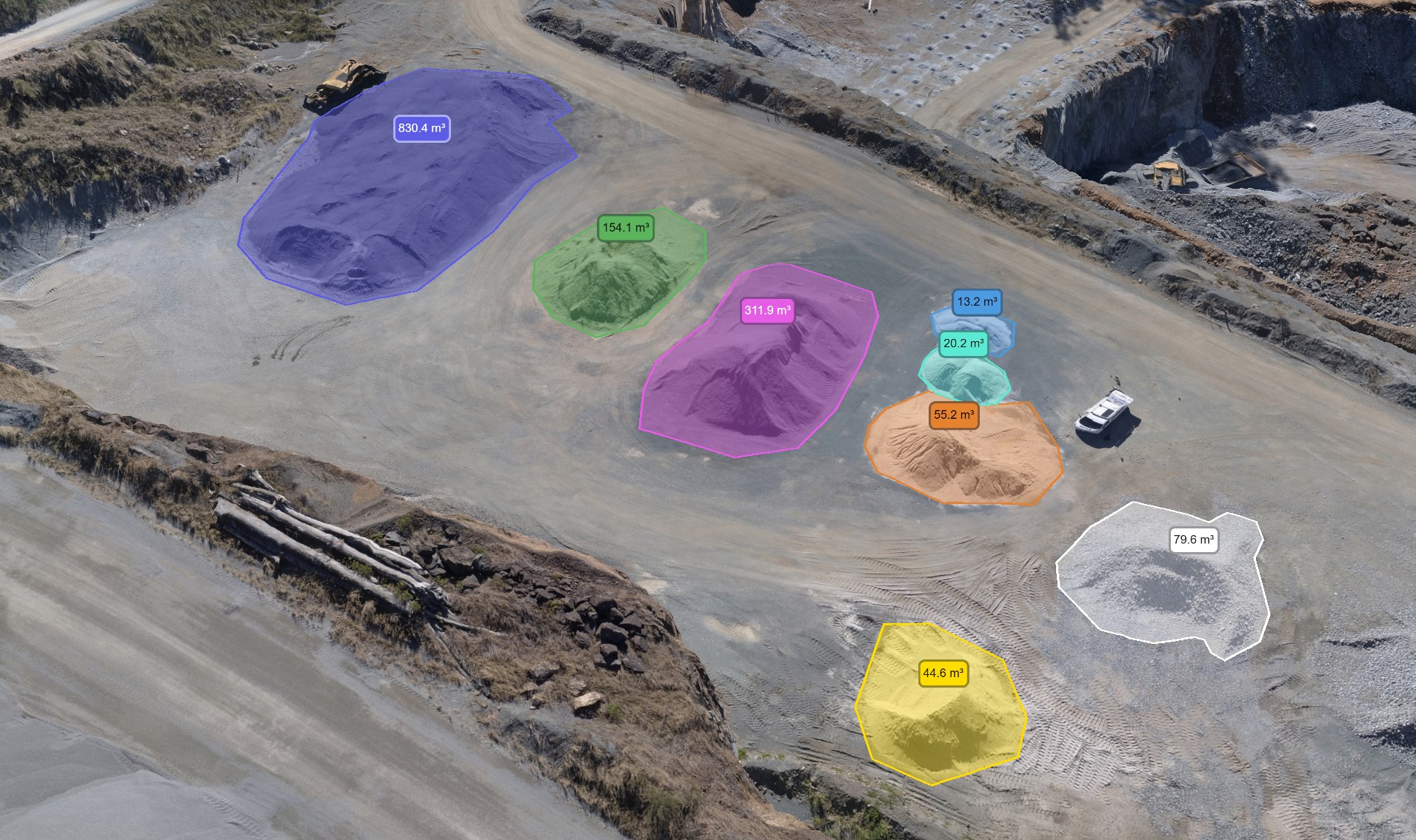
A drone flight captures the whole stockyard in one visit. The photographs are processed into a detailed 3D surface model, each stockpile is outlined on that surface, and its volume is calculated between the pile and an agreed base. Nobody needs to climb the material, and every pile on site comes from the same capture.
Typical uses
- Aggregate and material inventory
- Month-end and year-end stock reconciliation
- Monitoring material deliveries and removal
- Estimating material quantities for planning
- Regular measurements on a fixed schedule
- Supporting commercial and financial reporting
Every pile from one capture
Once the site has been flown, any stockpile on the surface model can be outlined and measured, including piles that would be unsafe or slow to survey on foot.

What you receive
- Stockpile volumesPDF, CSVIndividual measurements in cubic metres for every pile in scope
- Stockpile boundariesPDF, DXFEach pile outlined and labelled, so everyone can see exactly what was measured
- Volume reportPDFVolumes, survey date and the base surface used for each pile
- Annotated aerial imageryPDF, GeoTIFFAn aerial map of the stockyard with every pile marked
- 3D stockpile modelsBrowser linkA 3D view of the stockyard, where required
- Repeat measurementsPDF, CSVThe same piles measured on later visits to show the change
Cubic metres, tonnes and the base surface
A drone survey measures volume. Converting cubic metres to tonnes needs a bulk density for each material, and density varies with moisture, grading and how compacted the pile is. If you supply densities from your own testing or supplier data, tonnages can be added to the report with the densities stated alongside them.
Volume also depends on the base, or reference surface, beneath each pile. That might be a flat plane, a surface fitted to the ground around the pile or an earlier survey of the bare ground. The base is agreed before measurement and recorded in the report, so repeat measurements are calculated the same way every time.
Who uses it, and the decisions it supports
- Housebuilders and groundworks contractors
- Know what is on site before ordering more material or arranging removal.
- Quarry and aggregates operators
- Month-end and year-end stock figures for reconciliation and reporting.
- Quantity surveyors
- Measured, dated quantities to support valuations and stock checks.
- Recycling and waste operators
- Track stock levels of incoming and processed material between dates.
What it gives your team
Quicker stock checks
The whole stockyard is captured in one visit instead of pile by pile on foot.
Safer measurement
No one has to walk on loose material or work between moving plant.
Comparable figures
The same method and base surfaces on every visit make month-to-month figures consistent.
How the work is done
- ScopeWhich piles to measure, how the base should be defined, reporting dates and any material densities.
- PlanAirspace checks, a risk assessment and RAMS for the site, with a flight time agreed with the site team.
- CaptureThe site is flown with ground control and independent checkpoints measured with GNSS.
- ProcessA 3D surface is built and checked, then each pile is outlined and its volume calculated.
- ReportVolume report, marked-up imagery and data files, with a 3D view where required.
How accurate are drone stockpile measurements?
Accuracy depends on the capture and the conditions, so it is checked on every job rather than promised in advance. The aircraft flies with RTK positioning, ground control points and independent checkpoints are measured with GNSS, and the checkpoint results are reported with the volumes.
The biggest differences between two measurements of the same pile usually come from how the base is defined, which is why the base surface is agreed and documented each time.
What affects the result
- The base surface agreed for each pile
- Ground control and independent checkpoints
- Flight height and image overlap
- Standing water, deep shadow or plant parked against piles
- Piles inside buildings or under covers cannot be measured from the air
Indicative price
This is an introductory starting price for a straightforward project, not a fixed price for every site. Your quotation depends on the size and complexity of the site, travel, access, processing, ground control, reporting and the deliverables you need. VAT is additional.
Regular surveys at agreed intervals or project milestones are priced at a preferential rate per visit, because planning and set-up are shared and the same capture and control methods are used each time.
Frequently asked questions
How are stockpile volumes calculated?
The site is flown and processed into a detailed 3D surface. Each stockpile is outlined, a base surface is defined beneath it, and the volume is the space between the stockpile surface and that base. The report states the base used for each pile.
Can you calculate tonnes as well as cubic metres?
Yes, if a bulk density is available for each material. Density varies with moisture and compaction, so tonnages are only as reliable as the densities supplied. The report always shows the measured cubic metres and the density used for any conversion.
Can stockpiles be measured regularly?
Yes. Many sites measure monthly or at quarter end. Each visit uses the same method and base surfaces, so changes between dates reflect material moved rather than a change in approach.
What types of materials can you measure?
Aggregates, sand, soils, topsoil, crushed concrete, recycled materials, woodchip and other bulk materials stored in open piles. Piles need to be visible from the air, so material inside sheds or under covers cannot be measured.
How quickly will I receive the results?
Delivery times depend on the site, the survey requirements and the outputs you need. Inspection imagery can often be supplied the same day, and maps and 3D models can often be prepared within about two working days. More complex mapping and surveying deliverables may take around three working days or longer. Timescales are agreed for each project.
How much does a drone stockpile survey cost?
Straightforward stockpile volume surveys start from £650 + VAT. Your quotation depends on the size and complexity of the site, travel, access, processing, ground control, reporting and the deliverables you need. Regular surveys at agreed intervals or project milestones are priced at a preferential rate per visit, because planning and set-up are shared and the same capture and control methods are used each time.
Related services
All services